

Yes: your acreage foundation near Calgary depends heavily on which corner you build on, because the five main corridors sit on five different combinations of soil, bedrock, and water. Bearspaw is glacial till with expansive-clay pockets. Springbank has Bearpaw Formation shale near the surface and hillside seepage. Priddis mixes till with fluvial gravel. De Winton is deep prairie topsoil over till. Bragg Creek is creek-influenced and floodplain-prone. The concrete spec stays nearly the same across all five; what changes is everything around it.
Why “acreage near Calgary” isn’t one kind of ground
People say “acreage country” as if it were one place: a ring of similar lots with grass, a gravel approach, and a custom home going up somewhere down a long driveway. Below the topsoil, that picture falls apart. The land arcing northwest, west, southwest, and south of Calgary crosses five materially different geological situations, and the foundation that is straightforward on one corner can be a multi-step, multi-elevation, drainage-driven exercise on another.
If you are building the home you have worked your whole life for, on land you love, the question that should keep you up at night is not the kitchen finishes. It is whether the ground under the house will move. And the honest answer starts with a more specific question than most builders or crews will ask you: which corner are you on? Naming your specific corner, and explaining what it demands, is the difference between a crew that has solved a lot exactly like yours and one that is hoping yours behaves like the last one.
This piece walks the five corridors from a homeowner’s seat. (For the delivery-and-logistics side, such as drive times, the CSA discharge clock, and why volumetric concrete suits a long acreage drive, see our Omega Ready Mix companion piece, linked below; we won’t re-derive it here.)
The geology under all five corners, in one paragraph
Southern Alberta is a layer cake. On top sit the loose deposits the last glaciation left behind: glacial till (a dense, well-graded mix of clay, silt, sand, and stones), lake-bottom clays, and river gravels, plus the modern topsoil that grew on them. Beneath those sits Cretaceous bedrock, and in the Calgary region a lot of that bedrock is the Bearpaw Formation: dark grey marine clays, claystones, and shales laid down roughly 75 million years ago. The Bearpaw is the source of two things that matter to your foundation: the expansive (swelling) clay in the soil, and, where it sits near the surface, a bearing material that behaves very differently from ordinary soil. The acreage corridor crosses this layer cake at an angle, which is why your corner matters.
The Bearspaw vs. Bearpaw distinction (and why it tells you who knows your ground)
Here is a quick credibility test you can run on any crew or builder. Ask them the difference between Bearspaw and the Bearpaw Formation.
They sound nearly identical and they are completely different things. Bearspaw is the community northwest of Calgary; its ground is dominated by glacial till, and the Bearpaw Formation bedrock generally sits 10 metres or more below grade there and rarely outcrops. The Bearpaw Formation is the Cretaceous bedrock unit. The place where that bedrock most commonly sits at or near footing depth is Springbank, to the west — not Bearspaw. A crew that knows your ground knows that distinction cold, because it changes the foundation. A crew that uses the words interchangeably is telling you something.
The five corners at a glance
| Corner | Surface soil | Bedrock / water | What it drives in your foundation |
|---|---|---|---|
| Bearspaw (NW) | Clay-rich glacial till; expansive-clay pockets; lake-bottom clay in low lots | Cretaceous bedrock 10–30 m down; Bearpaw rarely outcrops | Walk-outs on sloped lots; expansive-clay management; large multi-elevation footprints |
| Springbank (W) | Thin till over bedrock on hillsides | Bearpaw shale at or near the surface; seepage zones common | Stepped foundations; hillside drainage; awareness of bentonite seams in the shale |
| Priddis (SW foothills) | Till plus river-gravel terraces plus clay lenses | Complex foothills bedrock; creek-influenced groundwater | Bearing that changes across the lot; floodplain detailing near creeks |
| De Winton (S prairie-edge) | Deep black topsoil (12–20 cm) over till | Cretaceous bedrock 10–30 m down; deeper water table | Topsoil stripping is non-negotiable; surface drainage on flat land |
| Bragg Creek (SW foothills) | Till plus river gravel/cobble plus alluvial fans | Floodplain risk (2013 flood); structurally complex bedrock | Site-access constraints; floodplain detailing; septic coordination |
Geology and jurisdiction sourced to the Alberta Geological Survey, Rocky View County, and Foothills County (below); the “what it drives” column reflects Omega 2000 Cribbing’s experience on these lots since 1988.
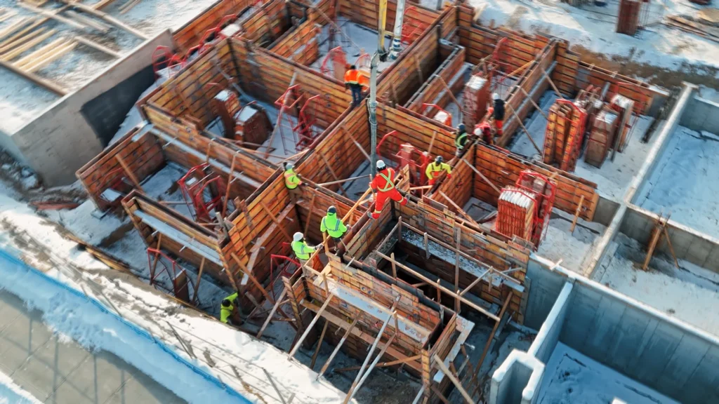
Corner 1 — Bearspaw (NW): till you can build on, clay you have to manage
Bearspaw is the established estate-acreage corner: large lots, mature shelterbelts, decades of custom homes. The dominant ground is glacial till, which is generally competent to bear a residential foundation. The complication is the expansive clay mixed through it: in lower lot positions especially, you find clay-rich till and lake-bottom clay lenses that swell when wet and shrink when dry, pressing on and pulling away from your foundation with the seasons.
What that means for your build: conventional footings and walls bearing on undisturbed till below frost depth, with the detailing complexity concentrated in three places: walk-outs on the sloped lots (stepped footings, multiple elevations), expansive-clay management where the geotech finds swelling clay near the bearing level (typically over-excavation and engineered granular fill, plus disciplined drainage and backfill), and the sheer size of Bearspaw footprints, which routinely run long with many corners and step-downs. The concrete spec does not change; the site prep around it does.
Corner 2 — Springbank (W): Bearpaw shale near the surface and hillside seepage
Springbank is where the ground gets genuinely demanding. The land slopes (hillside acreages, ridgeline view lots, drainage cutting through coulees), and on those hillsides the till thins until Bearpaw Formation shale sits at or near footing depth, sometimes outcropping outright.
Bearpaw shale is not ordinary bearing soil. It is a heavily over-consolidated clay shale, and the bentonite seams running through it are highly expansive when they meet water. That is why Springbank is also the seepage corner. The Alberta Geological Survey explains the mechanism precisely: “Contact springs occur at the contact of two layers of rock with sharply contrasting permeability such as a sandstone aquifer resting on top of shale… when the aquifer is exposed from erosion, the groundwater flows or seeps out” (Alberta Geological Survey — Springs). On a Springbank hillside, water that travels through a permeable layer hits the shale and emerges as seepage right where you are trying to keep a basement dry.
What that drives in your foundation: stepped foundations down the slope (multiple pour elevations), serious hillside drainage discipline (an engineered free-draining layer and positive grading, not just weeping tile), and design awareness of the bentonite seams in the Bearpaw where the geotech finds them near the bearing level. On a Springbank lot, the foundation is as much a water problem as a structural one.
Corner 3 — Priddis (SW foothills): bearing that changes across the lot
Priddis sits in the transition between prairie edge and foothills proper. The land rolls more, drainage cuts deeper, and the ground gets mixed: glacial till on the higher terrain, river-gravel terraces along the creeks and old drainage paths (excellent, free-draining bearing material when present), and clay lenses in the low spots. The water table swings sharply with the topography, and some creek-side lots carry floodplain risk.
What that drives: the geotechnical report matters more here, because a lot whose footings land on river gravel is a different design than the neighbour’s lot whose footings land on stiff clay till; sometimes the bearing material even changes across a single footprint. Add floodplain detailing on the creek-influenced lots (raised main-floor elevations, robust waterproofing, drainage that does not assume the creek behaves the way the old maps say) and the usual walk-out complexity on the rolling terrain. The mix spec holds; the design adjusts to whatever the geotech finds under each part of the house.
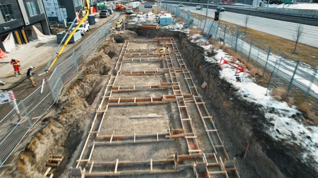
Corner 4 — De Winton (S prairie-edge): the foundation looks easy until the topsoil and the water
De Winton, between Calgary and Okotoks, is the flattest corner: prairie-edge benches, uniform-looking lots. The defining feature is the deep black topsoil (the Chernozemic A-horizon, 12–20 cm thick with 6–10% organic matter) developed on glacial till. The clay underneath carries the same expansive minerals you see in Bearspaw, in different proportions, and the water table is generally deeper.
The De Winton foundation problem is rarely bearing; it is topsoil and surface drainage. Two non-negotiables: strip the topsoil back to competent till before any footing goes in (pouring on a thick organic layer is a failure waiting to happen), and engineer the surface drainage, because on flat clay-rich ground water that reaches the foundation does not run away on its own. Get the grading, swales, and weeping-tile discipline right and a De Winton foundation performs; skip them and you have a wet basement on a lot that “looked easy.”
Corner 5 — Bragg Creek (SW foothills): the most constrained ground in the corridor
Bragg Creek, on the Elbow River system, is the most complex of the five: forested, dramatic topography, structurally deformed bedrock, river gravel and cobble along the watercourses, and more annual moisture than the prairie corners to the east. It is also the corner where floodplain risk is most real: the 2013 southern Alberta flood, which damaged a majority of Bragg Creek buildings, remains the defining reference for the area.
What that drives is constraint from several directions at once: site access (long, narrow, sloped, sometimes-soft driveways that dictate how concrete can even reach the pour), floodplain detailing where applicable (main-floor elevations above the regulatory flood level, waterproofing rated for higher water loads), and septic coordination, because the septic field design (with its setbacks from the house, property lines, water, and the creek) often pre-dates and constrains where the foundation can sit. Bragg Creek rewards a crew that has navigated its access and constraints before.
The one thing that does NOT change across all five corners: the spec
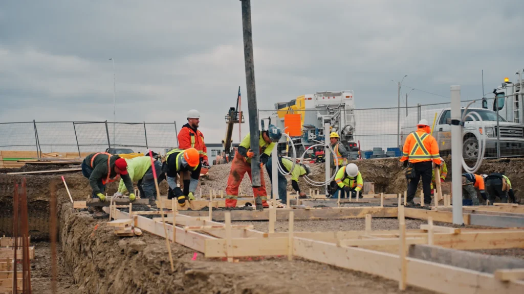
Here is the reassuring part. The geology decides the design and the detailing. The concrete spec is set mostly by regional chemistry and climate, and it is essentially the same across all five corners: S-2 sulphate exposure → Type HS (or HSe) cement; 32 MPa at 56 days as the CSA minimum (35 MPa is the common Calgary premium); 5–7% entrained air for freeze-thaw; footings below the ~1.2 m frost depth, all under CSA A23.1:24. (The chemistry of why Calgary needs Type HS is a story of its own; see our Type HS article, linked below.)
So when you compare quotes, the mix on the ticket should look the same whether your lot is in Bearspaw or Bragg Creek. What separates a foundation that lasts forty years from one that gives you trouble is not the concrete; it is the detailing around it: the bearing preparation, the drainage, the backfill discipline, the waterproofing, the grading, and the coordination with what the geotechnical report actually says about your corner.
Do I need a geotechnical report — and what does the County require?
For an acreage build, a geotechnical report is not optional paperwork; it is the document that turns “which corner you’re on” into a specific foundation design for your specific lot. And the County may require it.
- Rocky View County (Bearspaw, Springbank): the April 2025 Servicing Standards require geotechnical reports with County-specific content (geotechnical evaluation reports, required testing, authorship rules, and a preliminary slope stability evaluation), and the investigation must verify soil characteristics and groundwater conditions and confirm the site suits the proposed works (Rocky View County — Servicing Standards, April 2025).
- Foothills County (De Winton, Priddis): building permits are required for buildings over 107 sq ft, and on-site septic must comply with the Alberta Private Sewage Systems Standard of Practice (2021 edition) and CSA B66:21 (Foothills County — Building Permits & Inspections). (Note: the County page references an older 1999 edition of the sewage standard; the current edition is 2021, so confirm with the County at permit time.)
The report tells your crew the bearing capacity, the recommended bearing elevation, any expansive-soil or seepage treatments, the drainage recommendations, and (critically for Calgary) the water-soluble sulphate result that confirms the S-2 / Type HS requirement. A crew that reads it carefully and pours to it is the one you want on a forever home.
FAQ
Does my Calgary acreage foundation depend on which area I build in? Yes, significantly. The five main corridors (Bearspaw, Springbank, Priddis, De Winton, Bragg Creek) sit on five different combinations of soil, bedrock, and water, and each drives different foundation detailing: walk-outs and expansive clay in Bearspaw, shale and seepage in Springbank, variable bearing in Priddis, topsoil and drainage in De Winton, floodplain and access in Bragg Creek. The concrete spec stays nearly identical; the detailing around it changes.
What is the Bearpaw Formation and why does it matter for my foundation? The Bearpaw Formation is a roughly 75-million-year-old Cretaceous bedrock unit of dark grey marine clays and shales beneath much of southern Alberta. It matters two ways: it is the source of the expansive (swelling) clay in the soil, and where it sits near the surface (most commonly in Springbank) it is a bearing material that behaves differently from ordinary soil, with highly expansive bentonite seams.
Is Bearspaw the same as the Bearpaw Formation? No. Bearspaw is the community northwest of Calgary, where the ground is glacial till and the Bearpaw bedrock generally sits 10+ metres down and rarely outcrops. The Bearpaw Formation is the bedrock unit itself, which most commonly reaches footing depth in Springbank, to the west. The names are nearly identical; the ground is not.
Why do Springbank hillside lots have seepage problems? Because of contact springs. The Alberta Geological Survey describes them as occurring where a permeable layer (like a sandstone aquifer) sits on a much less permeable one (like Bearpaw shale); groundwater travels through the permeable layer and seeps out where it’s exposed. On a Springbank hillside that exposure point can be right where you’re trying to keep a basement dry, which is why hillside drainage detailing is so important there.
Do I need a geotechnical report to build on acreage near Calgary? In most cases yes, and it may be required. Rocky View County’s April 2025 Servicing Standards require geotechnical reports (including a preliminary slope stability evaluation) for development in Bearspaw and Springbank. The report establishes bearing capacity, recommended bearing elevation, expansive-soil and drainage treatments, and the sulphate result that confirms the Type HS requirement. It is what turns regional patterns into a design for your specific lot.
What does Rocky View County require before I build on a Bearspaw or Springbank lot? Under the April 2025 Servicing Standards, a geotechnical report with County-specific content (geotechnical evaluation report, required testing, authorship rules, and a preliminary slope stability evaluation) verifying soil characteristics and groundwater conditions and confirming the site suits the proposed works. Confirm the current requirements with the County, as standards are updated.
Is the foundation concrete spec different on acreage than in the city? Generally no. Most of the Calgary region, city and acreage alike, falls into the S-2 sulphate class, so the spec is Type HS or HSe cement, 32 MPa at 56 days as the CSA minimum (35 MPa is the common premium), and 5–7% entrained air under CSA A23.1:24, with footings below ~1.2 m frost depth. What changes on acreage is the site detailing (drainage, bearing prep, walk-outs, floodplain and septic coordination), not the mix.
Why is volumetric concrete often better for a long acreage drive? Because CSA A23.1 limits the time from batching to placement to two hours (with a 90-minute air-content retest threshold), and a 45-to-60-minute acreage drive can consume more than half of that clock before the truck arrives. Volumetric concrete is batched at the truck on arrival, so the clock starts at the lot: a CSA compliance posture, not just “fresher concrete.” Our Omega Ready Mix companion piece covers the delivery physics in full.
Before You Pour, Know What Your Ground Is Doing
Every acreage corner near Calgary behaves differently below grade. A foundation that works in Bearspaw may fail on a Springbank hillside or a creek-side Bragg Creek lot.
Before excavation starts, we help homeowners understand:
- what the geotechnical report actually means,
- what drainage and bearing conditions will drive the design,
- and what your site demands before concrete arrives.
Planning an acreage build near Calgary? Talk to Omega 2000 Cribbing before your foundation design is finalized.
Book a foundation consultation with Omega 2000 Cribbing today!